by Libby Hsieh
The Portuguese named Taiwan “Ilha Formosa” (beautiful isle), and appropriately Taiwan is known for its beautiful mountains and therefore is home to many low-altitude and high-altitude hiking trails. Since the pandemic, people may think that it is time to get some fresh air but at the same time still want to keep social distance from others. Open spaces like visiting some of the recommended hiking trails during weekends are the best and safest options. Exercising, viewing great scenery, and getting closer to nature all at the same time are possible with these hiking trails.
Wujiutongshan Footpath (difficulty ⭐️)
For beginners and those who are not regular hikers, the Wujiutongshan hiking trail in Taoyuan is located on a relatively low-altitude hill. Wujiutongshan literally means “five wine barrels mountain.” According to Taoyuan Tourism, during the Ming dynasty, a local resident Mr. Tsai and his 5 alcoholic sons often drank barrels of wine once since they moved to Wujiutongshan. This hiking trail has smooth paths and wide stone steps. Visitors will find a limitless coastline view along this trail.
Directions: Taoyuan MRT to Shanbi Station. Then take bus no.L302, L302A, L302B, and get exit at Xinrenrenguo Station. Or take bus no. 209, 5014, 5016, 5020, 5021, 5069, 5071, or 5073 bus and get exit at Cement Company Station
Jiangziliao Hiking Trail ( difficulty ⭐️)
A slight trail, a crystal clear stream, and spaces scented with phytoncide all comprise the natural beauties of the captivating Jiangziliao hiking trail which is suitable for the whole family. Visitors will encounter waterfalls and great cliffs along the smooth footpaths which allow for a slower pace, helping visitors to reach a sense of calm and inner peace. This trail is the perfect escape from a hurly-burly lifestyle.
Directions: Exit at Xizhi Railway Station, take bus no. F905 and disembark at Jiangziliao stop.
Shihmen Mountain Trail Entrance no. 1 ( difficulty ⭐️⭐️)
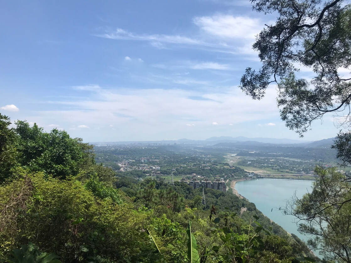
Shihmen Mountain was originally named Xiao Zhukeng mountain and later became famous due to the establishment of Shihmen Reservoir in 1956. Located on the west of Shihmen Dam with an elevation of about 551 meters with no barriers, visitors can directly overlook the beautiful scenery of the reservoir and the nearby Longtan and Daxi streets. If the skies are clear, visitors will be in luck and get to see Taipei 101. However, Hikers should be cautious of the Heroic Slope, which is only 400 meters short but with a gradient drop of nearly 200 meters. There are climbing ropes to continue forward. With a slow and cozy pace ascending towards the peak, visitors can appreciate the natural forest of acacia, tung trees, and ferns. A sense of accomplishment and excitement await those who conquer the Shihmen Mountain hiking trail.
Direction: Take the Taiwan Railway and disembark at Zhongli Station to transfer to Taiwan Tourist Shuttle 503 Shimen Reservoir Line (available on holidays) to Shimen Station (top of the dam).
Shihmen Mountain Trail, photograph by Libby Hsieh
Old Tianmu Hiking Trail (difficulty ⭐️⭐️)
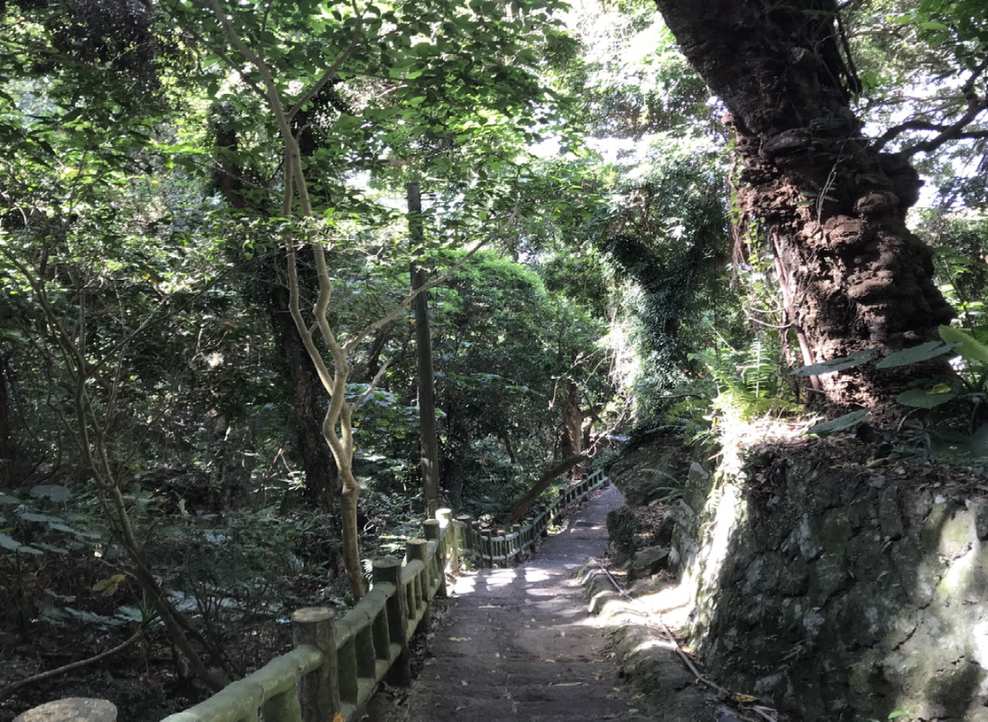
To access the mountain pass of the trail, visitors must first pass through the nearby residential area for approximately five minutes. The trail officially begins with a road sign of the Tianmu Trail. It is a rather popular hiking trail situated in Taipei City, therefore visitors need not worry about getting lost. Starting from the entrance, visitors need to climb 1300 steps to reach a pavilion. After passing the Adjustment Well, a landmark in Taipei, visitors will find a flat forest bathing trail. Here, visitors can wander the lush forest, experience the tranquility and primitiveness of nature, and learn about the rich cultural and historical features of the Tianmu Ancient Road from the signs. However, despite being a meaningful site, this trail’s shortcoming is the abundance of mosquitoes. Visitor Joanne Chiang cautioned, “Visitors must remember to put on mosquito repellent.” As Chinese Culture University is right next to the hiking trail, so visitors can stop by and recharge at a cafe inside the university.
Directions: Taipei MRT to Shipai Station and then transfer to Tianmu Bus to the terminal station.
Old Tianmu Hiking Trail, photograph by Libby Hsieh
Jinmianshan Hiking Trail ( difficulty ⭐️⭐️⭐️)
Located in the Neihu District of Taipei, this trail is highly recommended for its view of Taipei’s cityscape.The name of Jinmian Mountain derives from the quartz within the andesite, which sparkles under the sun. As Jinmian Mountain is only 258 meters above sea level, the trail is easy to walk at the beginning, and it takes about 30-40 minutes to reach the apex. Going up to Lunjian Pavilion, visitors will see Songshan Airport. Then as hikers pass by Chongyang Pavilion, they will find the most difficult portion of the whole journey. Even though the trail becomes rocky, there are footsteps carved out by previous hikers on the stone surface, and ropes to hold onto stationed along the path. In 10-20 minutes, visitors will arrive at Lun Jian Pavilion, which is just a few steps away from the top, marked by the famous scissors stone.
Directions: Taipei MRT to Xihu Station, and walk for about 15-20 minutes to reach the mountain trail entrance.
