by Shona Song
Due to the impact of the Covid-19 pandemic, people tired of being trapped downtown may wish to explore the hundreds of mountains to have unforgettable adventures. In the slightly less than 36 thousand square kilometers of Taiwan, two-thirds of which are covered by mountains and forests, Taiwan's One Hundred Mountains (台灣百岳) are important sites for mountaineering enthusiasts for their strange, challenging, and beautiful features.
Mt. Qilai is one of the easiest mountains to access, and it has marvelous features, such as the sea of clouds, nighttime views of the Milky Way, a wide range of flora and even fauna, and more.. Located between Hualien County, and Nantou County, Mt. Qilai is in the Central Mountain Range within the Taroko National Park’s Ecological Protection Area. It has a few peaks, Qilai Main Peak at 3560m, Qilai North Peak at 3607m, and Qilai South Peak at 3358m.
Even though Qilai is at the entry-level for climbing One Hundred Peaks, it is not at a beginner’s level hike. According to the Central News Agency (CNA), Mt. Qilai is one of those mountains with the highest risk of mountaineering accidents; therefore complete novices should not hike alone, and should be accompanied by a professional guide in case of any accidents. But those who prefer to be solo hikers must have advanced mountaineering skills and have experience with hiking challenging peaks in extreme weather, road conditions, and minimal visibility.
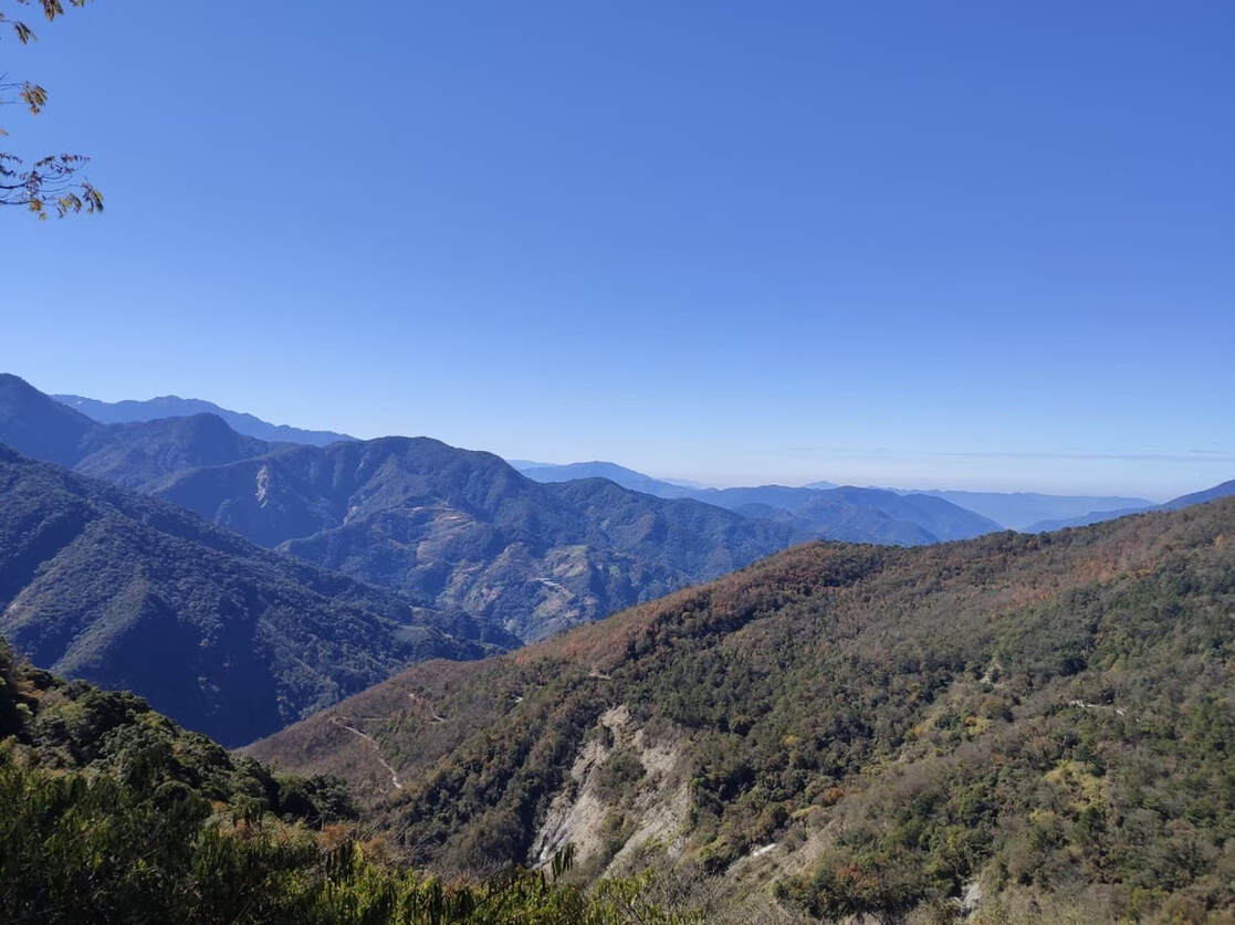
View in Qilai Mountain, photograph by Shona Song
Hiking in the mountains is different from simple traveling. Mountain hiking means that hikers must pack and carry all needed equipment, including hiking boots, weather-appropriate clothes, a packable down jacket, headlamp, gloves, alpenstock, rain gear, toiletries, etc., but keeping in mind that one of the main principles of packing is to be sufficient and light.
To get through the trailhead, hikers are required to show a mountain access permit, which must be applied for one month in advance. Weather conditions and temperatures in Mt. Qilai can change dramatically and quickly, so before going into the mountains, hikers must pay special attention to weather conditions and dress accordingly. During the winter, road conditions near the summit are unpredictable; therefore, some equipment like ice axes and crampons could ensure safety and convenience.
There is no public transportation to Tunyuan trailhead. The closest bus stop is in Puli Township. From Taichung Station, hikers can either rent a car or take an Uber to the trailhead but those who hire a guide might have that service included depending on the package purchased.
In the mountain, there is only one accommodation, Tianchi Lodge (天池山莊). Mountaineers need to draw lots for campsites on its official website. If they fail to reserve one, they would have to pack their tents and sleeping bags.
The South Peak and Mt. Nanhua
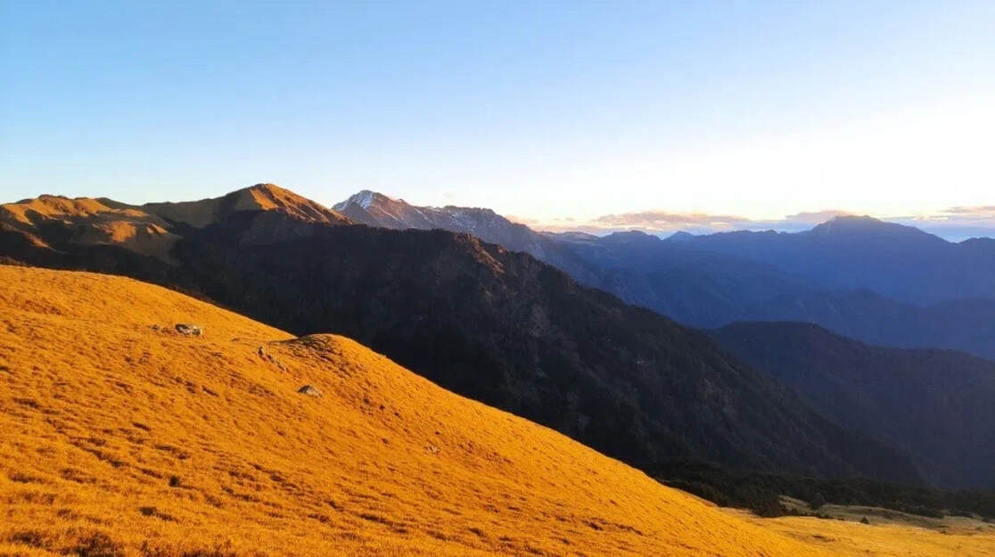
The Taluoro Cliff separates the South Peak from the Main Peak. The South Peak is always combined with Mt. Nanhua as a climbing package, which is most recommended by the guide JJ since it has the best road conditions and the most beautiful scenery. Deputy Director of Photography Agency and photographer, ManJyu, says that the first stop in this trail is the Yunhai Security Line. After crossing the green and undulating bamboo grassland, following the zigzag footpath to pick up steps, hikers can reach the summit of the endless, flat Qilai South Peak. There visitors will be greeted with a stunning view of a golden prairie under the rising sun. If hikers are lucky, the first rays of dawn on the eastern horizon will also encompass all that can be seen with their magnificent radiance.
The road from Tianchi Lake to the Nanhua Mountain is like a thousand miles of green carpet, as far as the eye can see. Nenggao Mountain, Qilai Mountain, Snow Mountain, Hehuan Mountain, and other peaks surround the summit; to the east, hikers can see a series of V-shaped valleys; and to the west is Mount Lushan and Qingjing Pasture.
On rainy days, there might be an increased risk of accidents. But the beauty of the silence and desolation in the rainy Qilai mountain is incredible. Looking down the cliff, the mist slowly rises from the valley. Under the heavy rain and fog, it seems as if rootless trees are floating in the clouds, reaching into the heavens.
View in Qilai Mountain, photograph by Shona Song
Qilai Main Peak and North Peak
This trail usually takes 2-3 days to complete, and it is the most standard routine for climbing Mt. Qilai. One of Taiwanese Ten Glories, the North Peak is a classic triangular-shaped mountain peak with cliffs surrounding it from the north, west, and south. The prairies continue further towards Mt. Panshi (磐石山) on the east. It is composed of scattered rocks among greenland with bamboo, presenting a unique view.
Mt. Qilai Main Peak sits at an elevation of 3,560 meters. Like the North Peak, this peak is similarly precipitous: the ridge leading towards the North and South Peaks follows two separate cliffs.
Safety issues
JJ, a guide from Taiwan 368, says that Mt. Qilai is also famous for its nickname among locals as Black Qilai (黑色奇萊), a nickname earned through the disasters that happened to hikers back in the early 70s and 80s. At the summits of the North Peak and Main Peak, there are still some remembrance marks (紀念碑) to memorialize those who unfortunately fell off the cliffs near the summits. Hikers must remember to rest, rehydrate, and pay close attention to their wellbeing, especially the condition of their legs and knees.
JJ, a guide from Taiwan 368, says that Mt. Qilai is also famous for its nickname among locals as Black Qilai (黑色奇萊), a nickname earned through the disasters that happened to hikers back in the early 70s and 80s. At the summits of the North Peak and Main Peak, there are still some remembrance marks (紀念碑) to memorialize those who unfortunately fell off the cliffs near the summits. Hikers must remember to rest, rehydrate, and pay close attention to their wellbeing, especially the condition of their legs and knees.
